


NEW ORLEANS -- Gulf Coast residents scrambled to finalize storm preparations as Hurricane Nate raced
swiftly over the central Gulf of Mexico on Saturday, gaining added
strength as forecasters said it would smash into the U.S. coast during
the night.
Louisiana's governor urged his state's residents to
take Nate seriously, saying the storm "has the potential to do a lot of
damage."
"No one should take this storm lightly. It has already
claimed the lives of at least 20 people," Gov. John Bel Edwards said
Friday. "We do want people to be very, very cautious and to not take
this storm for granted."
A hurricane warning is in effect from
Grand Isle, Louisiana, to the Alabama-Florida border and also included
metropolitan New Orleans nearby Lake Pontchartrain. A tropical storm
warning extended west of Grand Isle to Morgan City, Louisiana, and
around Lake Maurepas and east of the Alabama-Florida border to the
Okaloosa-Walton County line in the Florida Panhandle.
States of
emergency were declared in all three states as Nate -- which has already
killed at least 21 people in Central America -- became the latest in a
succession of destructive storms this hurricane season.
Follow along with the latest updates below. All times are Eastern unless otherwise noted.
1:10 p.m.: Louisiana cuts early voting short for hurricane
Early voting is wrapping up sooner than scheduled in parts of Louisiana because of Hurricane Nate.
Meg
Casper Sunstrom, spokeswoman for the secretary of state's office, said
voters in some southeastern parishes will have until 3 p.m. on Saturday
to cast their ballots early. The parishes affected are in the New
Orleans-area, including Orleans, St. Bernard, Plaquemines and St.
Tammany parishes.
Early voting will close as scheduled at 6 p.m. local time in the state's other parishes.
Saturday
is the last day of the week-long early voting period. Louisiana has a
statewide election Oct. 14, and New Orleans has a hotly contested
mayor's race on the ballot.
12:30 p.m.: Alabama under tropical storm warning
The National Weather Service is placing much of Alabama under a tropical storm warning.
Forecasters
said Saturday that Hurricane Nate could bring wind gusts of up to 60
mph across much of the central part of the state, which includes
Birmingham, the state's largest city.
The storm is expected to down trees and cause significant power outages. Isolated tornadoes were also possible Sunday afternoon.
On
Alabama's Gulf coast, some communities have already imposed mandatory
curfews from Saturday evening through Sunday morning. They've also
ordered beaches and fishing piers closed and issued voluntary evacuation
orders.
On Florida's Panhandle, officials have ordered
evacuations in some low-lying areas. They're also warning beachgoers to
stay out of the Gulf of Mexico as the storm is already whipping up
deadly rip currents and rough surf.
12:22 p.m.: New Orleans prepares for Nate's storm surge
CBS News correspondent Michelle Miller is in New Orleans
and reports that a mandatory curfew goes into effect at 7 p.m. local
time Saturday. Mayor Mitch Landrieu issued mandatory evacuation orders
for areas outside of the city's storm protection system.
City
officials closed off about 200 floodgates on Friday night, ahead of a
storm surge that could be as high as 10 feet, Michelle reports.
Water
is already spilling onto streets in the city's Venetian Isles
neighborhood from an unusually high tide. Residents had until noon
Saturday to leave.
"Can't call anybody, not coming, so it is a good idea to leave for most people," one resident told Miller.
Others
have already left their homes. The first evacuees began arriving at one
shelter in Plaquemines Parish. About 20 were there by late Friday night
with more expected to come.
"They take very good care of us
opening these centers so we can have a place to go, and I appreciate
that," East Bank resident Betty Duplessis told Miller.
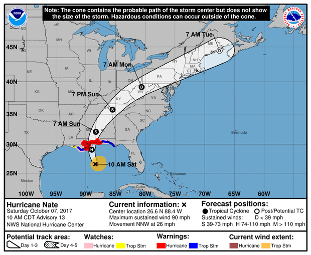
11:06 a.m.: Nate expected to make landfall as Category 2 storm, NHC says
Strengthening Hurricane Nate is now expected to be a Category 2 hurricane at landfall on the central Gulf Coast in coming hours.
The National Hurricane Center in Miami says
Nate's top sustained winds have recently risen to 90 mph and the core
is now about 180 miles south-southeast of the mouth of the Mississippi
River.
As
of 11 a.m. Saturday, Nate was accelerating to 26 mph and headed
north-northwest on a course expected to take it onto the central Gulf
Coast on Saturday night. Forecasters say the hurricane-force winds
extend out up to 35 miles, mainly to the east of the eye.
In
addition to hurricane warnings and tropical storm warnings already in
place along a wide stretch of Gulf Coast, a new tropical storm warning
has been issued in the Florida Panhandle from east of the
Okaloosa-Walton County line to Indian Pass, Florida.

Hurricane Nate expected to make landfall on Gulf Coast as Category 2 -- live updates
![Hurricane Nate expected to make landfall on Gulf Coast as Category 2 -- live updates]() Reviewed by info_impromises
on
October 07, 2017
Rating:
Reviewed by info_impromises
on
October 07, 2017
Rating:


No comments: